
AGRICULTURE
For applications where the cost of a differential GNSS system is not justified, or if the rover stations are spread over too large an area, an SBAS may be more appropriate for enhancing position accuracy.
SBAS are geosynchronous satellite systems that provide services for improving the accuracy, integrity and availability of basic GNSS signals:
SBAS include reference stations, master stations, uplink stations and geosynchronous satellites, as shown in Figure 42.
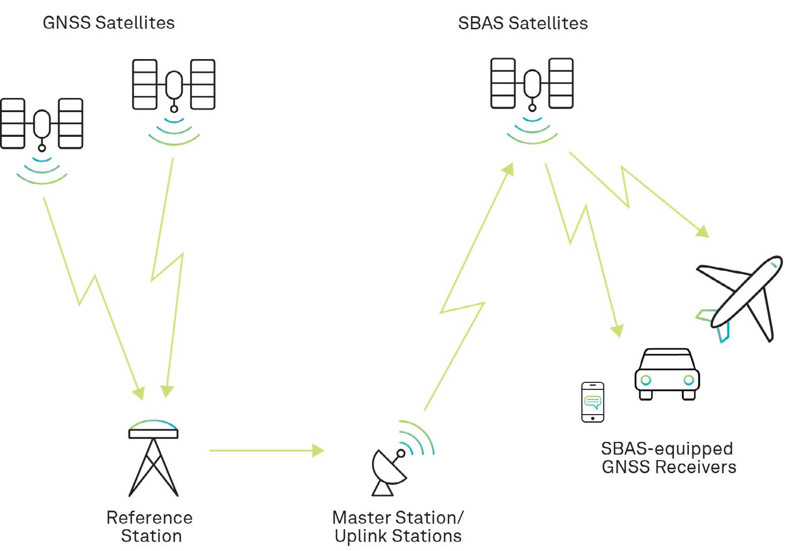
Reference stations, which are geographically distributed throughout the SBAS service area, receive GNSS signals and forward them to the master station. Since the locations of the reference stations are accurately known, the master station can accurately calculate wide-area corrections.
Corrections are uplinked to the SBAS satellite and then broadcast to GNSS receivers throughout the SBAS coverage area.
User equipment receives the corrections and applies them to range calculations.
The following sections provide an overview of some of the SBAS services that have been implemented around the world or that are planned.
The U.S. Federal Aviation Administration (FAA) has developed the WAAS to provide GPS corrections and a certified level of integrity for the aviation industry, enabling aircraft to conduct precision approaches to airports. The corrections are also available free of charge to civilian users in North America.
A Wide-Area Master Station (WMS) receives GPS data from Wide-Area Reference Stations (WRS) located throughout North America. The WMS calculates differential corrections and then uplinks these to two WAAS geostationary satellites for broadcast across North America.
Separate corrections are calculated for ionospheric delay, satellite timing and satellite orbits, which allows error corrections to be processed separately, if appropriate, by the user application.
The WAAS broadcasts correction data on the same frequency as GPS, which allows for the use of the same receiver and antenna equipment as that used for GPS. To receive correction data, user equipment must have line of sight to one of the WAAS satellites.
The European Space Agency, in cooperation with the European Commission (EC) and EUROCONTROL (European organisation supporting European aviation), has developed the EGNOS, an augmentation system that improves the accuracy of positions derived from GPS signals and alerts users about the reliability of the GPS signals.
The EGNOS system augments GPS signals over Europe and North Africa. EGNOS transmits an open service to the EU member states, plus Norway and Sweden, and a safety-of-life service to the European Civil Aviation Conference (ECAC) Flight Information Regions.
In a future upgrade, the EGNOS system will also support Galileo signals.
The BDSBAS system is an extension of the BeiDou GNSS system. It provides accuracy improvements and integrity service to users in China and the surrounding area.
MSAS is an SBAS that provides augmentation services to Japan. It uses two Multi-functional Transport Satellites (MTSAT) and a network of ground stations to augment GPS signals in Japan.
GAGAN is an SBAS that supports flight navigation over Indian airspace. The system is based on three geostationary satellites, 15 reference stations installed throughout India, three uplink stations and two control centres. GAGAN is compatible with other SBAS systems, such as WAAS, EGNOS and MSAS.


