AGRICULTURE
What is the difference between GNSS vs. GPS? The easiest way to think of it is that GPS is a type of GNSS.
While the terms are often used interchangeably, like how Band-Aid is used synonymously to refer to any adhesive bandage, there are some differences between the two. Let's start with some basic terminology.
GNSS stands for Global Navigation Satellite Systems. It is a generic term used to describe the collection of satellite constellations in operation.
Constellations are groups of satellites orbiting the Earth, working together for a specific function, namely to support highly accurate positioning, navigation and timing (PNT) measurements worldwide.
Satellites are deployed in constellations because they provide more continuous coverage of an area compared to a single satellite. Essentially, at any given time, multiple satellites are visible from any place on the Earth’s surface.
Satellite constellations operate in one of three orbits or regions in space:
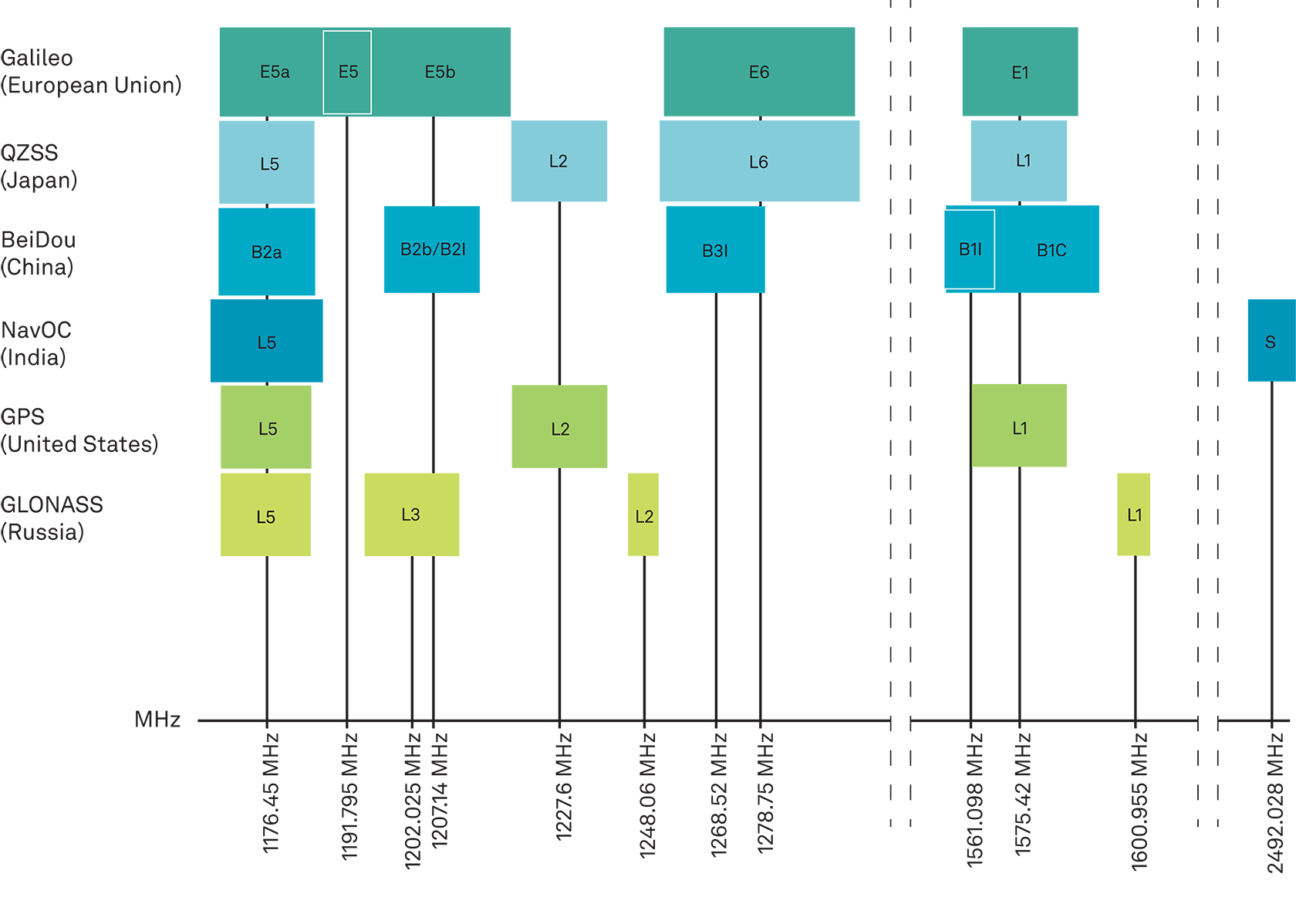
These satellite constellations use radio frequencies in the L-Band to transmit their signals. However, each constellation may choose different frequencies and corresponding labels for these signals. GNSS positioning equipment typically receives at least two frequencies. As the number of constellations and signals increases, the more complex the GNSS spectrum becomes.
GPS stands for Global Positioning System. It was the first GNSS system and was launched in the late 1970s by the U.S. Department of Defense and is currently operated by the US Space Force. Today, it is the most widely used GNSS in the world and provides global coverage. It is one of four constellations currently orbiting the Earth and has approximately 31 satellites in orbit.
So, back to our original question. While GNSS and GPS can and do work together, the main difference between them lies in the equipment required to use them. For example, GNSS receivers can access satellites from different constellations, while GPS receivers may only be able to receive signals from satellites in the GPS system. Added to that, a multi-constellation, multi-frequency GNSS receiver gets signals from many different systems at the same time, offering more accurate, redundant and available coverage.
Instead of GNSS vs. GPS, a better way to consider these technologies is how GPS compares to other GNSS constellations. There are currently four global and two regional constellations, each operated by different countries. While the basic concept of how constellations work is the same there can be some key differences in how they operate that are important to note. This includes the number of satellites, their orbital planes, frequencies, signals, etc. The below table summarises the key characteristics of each constellation.
| System | GPS | GLONASS | Galileo | BeiDou | QZSS | NavIC |
|---|---|---|---|---|---|---|
| Country of origin | United States | Russia | European Union | China | Japan | India |
| Coverage | Global | Global | Global | Global | Regional | Regional |
| Number of MEO satellites | 31 | 24 | 30 | 29 | 4 | 7 |
| MEO altitude | 20,200 km | 19,140 km | 23,222 km | 21,528 km | 32,000 – 40,000 km | 36,000 km |
| Orbital planes | 6 | 3 | 3 | 3 | ||
| Frequency bands | L1, L2, L5 | L1, L2, L3 | E1, E5a, E5b, E6 |
B1C, B1l, B2l/B2b, B2a, B3l | L1, L2, L5 L6 |
L5, S |
Interested in learning more? Take a deeper dive into the constellations that make up the global and regional GNSS network in What are Global Navigation Satellite Systems? or Chapter 3 of our Introduction to GNSS book.