What is ionospheric activity?
The ionosphere is part of the Earth’s atmosphere located between 50 to 1000 km above the Earth’s surface. This layer contains free electrons, especially at altitudes between 250 to 400 km, that can adversely affect the performance of GNSS receivers.
We are currently within a period of increased ionospheric activity. As a result, more frequent and greater adverse effects to GNSS tracking and positioning can be expected at certain times and in certain environments.
Ionospheric activity is influenced by the periodic cycles of solar activity, the Earth’s tilt/orbit (annual), the Earth’s rotation (daily), as well as interaction with the Earth’s magnetic field. Increased ionospheric activity is correlated with the following factors.
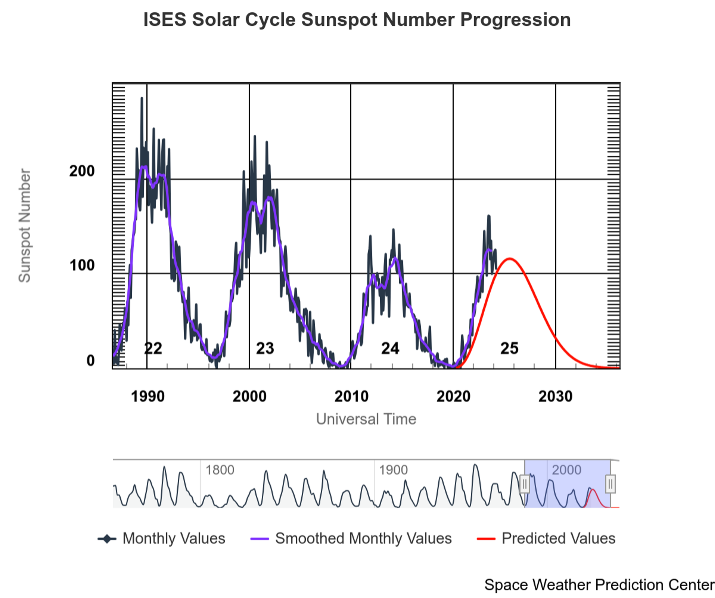
- Sunspot Activity: Increased sunspot activity, which is linked to the 11-year solar cycle. The sunspot count can be monitored on websites such as the NOAA Space Weather Prediction Center. The chart below illustrates the measured (black line) and predicted (red line) sunspot activity for the current solar cycle 25.

(U.S. Department of Commerce, NOAA & SWPC, 2024)
- Solar Storms: Increased probability of solar storms and flares (powerful X-class) and coronal mass ejections (CME). Satellites monitor the surface of the sun that points towards the Earth and provide early warning alerts of earthbound emissions.
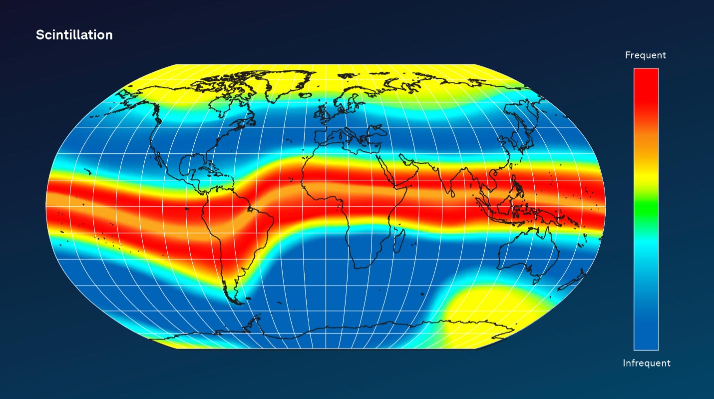
- Location: The highest ionospheric activity is seen ±20 degrees around the geomagnetic equator and, less severely, in auroral (polar) regions.

(Based on Kintner et al., 2009)
- Seasonal Variations: Increased ionospheric activity is observed at the spring and autumn equinoxes.
- Diurnal (Daily) Variations: Maximum ionospheric effects are experienced after local sunset until midnight.
How is GNSS impacted?
As a GNSS signal passes through charged particles in the ionosphere, the signal is delayed. The magnitude of the ionospheric delay is a function of the refractive index of the ionosphere in the path of the GNSS signal. The refractive index is a function of the signal frequency and total electron content (TEC) in the signal path. The TEC will vary depending on the latitude of the receiver, time of day, season, and level of solar activity as detailed above.
In addition, ionospheric scintillation is a rapid temporal fluctuation in both amplitude and phase of a GNSS signal due to localized irregularities in electron density. These irregularities can cause both refraction and diffraction of GNSS signals.
The current increase in ionospheric activity has two main effects.
- The most significant effect is scintillation, which can prevent or degrade tracking of satellites most commonly around the geomagnetic equator after local sunset. This results in a reduced number of usable GNSS satellites and occasionally a reduction in the L-Band communications link strength, causing intermittent reception of corrections. The number of satellites affected depends on the size of the scintillation area, the user’s position, and the location of the satellites. A reduction in the number of usable GNSS measurements will increase PPP and RTK initialisation/convergence times and reduce position accuracy in all positioning modes.
- Increases and rapid changes in ionospheric delay impacts single-frequency position solutions including Differential GNSS (DGNSS), SBAS and single point. The overall impact is a significant increase in the positioning error.
How can I mitigate the effects?
The following actions are recommended to help mitigate the impacts to your operation.
- Ensure you are registered to receive warning emails from TerraStar support. Monitor emails carefully for warnings of high-space weather activity. A significant risk is the occurrence of large X-class flares and CME events. Warning emails are based either on forecasts or events and provide advanced warning ranging between 3 and 30 hours.
- Upgrade single-frequency solutions to dual- or triple-frequency to remove ionospheric errors. TerraStar and Oceanix PPP solutions are recommended instead of single-frequency solutions in areas affected by high ionospheric activity, including equatorial regions.
- Use additional GNSS constellations (GLONASS, BeiDou, Galileo) to increase the number of observations available to the positioning solution and increase the diversity of the signals tracked. For TerraStar customers, this means upgrading to TerraStar-C PRO and using the latest firmware. In particular, the latest 7.09.01 and 7.09.02 firmware releases provide significant improvements to positioning accuracy and availability during scintillation.
- Where possible, ensure the GNSS tracking mask is set to 10 degrees as ionospheric activity has the largest impact on satellites closest to the horizon.
- Track all available L-Band beams to ensure that corrections can still be received if lock to one satellite is lost. Multiple L-Band beam tracking is the default on all OEM7-based receivers. Where available, IP correction delivery (NTRIP) should also be used as a backup.
Although these steps may mitigate the adverse effects of increased ionospheric activity, in extreme scintillation scenarios all GNSS and L-Band signals may be impacted, resulting in degradation or even total loss of GNSS positioning.
Any questions can be directed to NovAtel support: support.novatel@hexagon.com
References
NOAA SWPC Space Weather Dashboard
U.S. Department of Commerce, National Oceanic and Atmospheric Association (NOAA) & Space Weather Prediction Center (SWPC). (2022, December 15). ISES Solar Cycle Sunspot Number Progression [Chart].
Kintner P., Humphreys T., Hinks J. (2009). GNSS and ionospheric scintillation. Inside GNSS 4:22–30

