
AGRICULTURE
As outlined in Chapter 1, there are multiple constellations of GNSS satellites orbiting the Earth. A constellation is simply an orderly grouping of satellites in orbits that have been designed to provide a desired coverage, for example, regional or global. We will provide more details about GNSS constellations in Chapter 3.
GNSS satellites orbit well above the atmosphere, about 19,000 to 36,000 kilometres (11,800 to 22,400 miles) above the Earth’s surface. They move very fast; GPS satellites move 3.9 km/second.
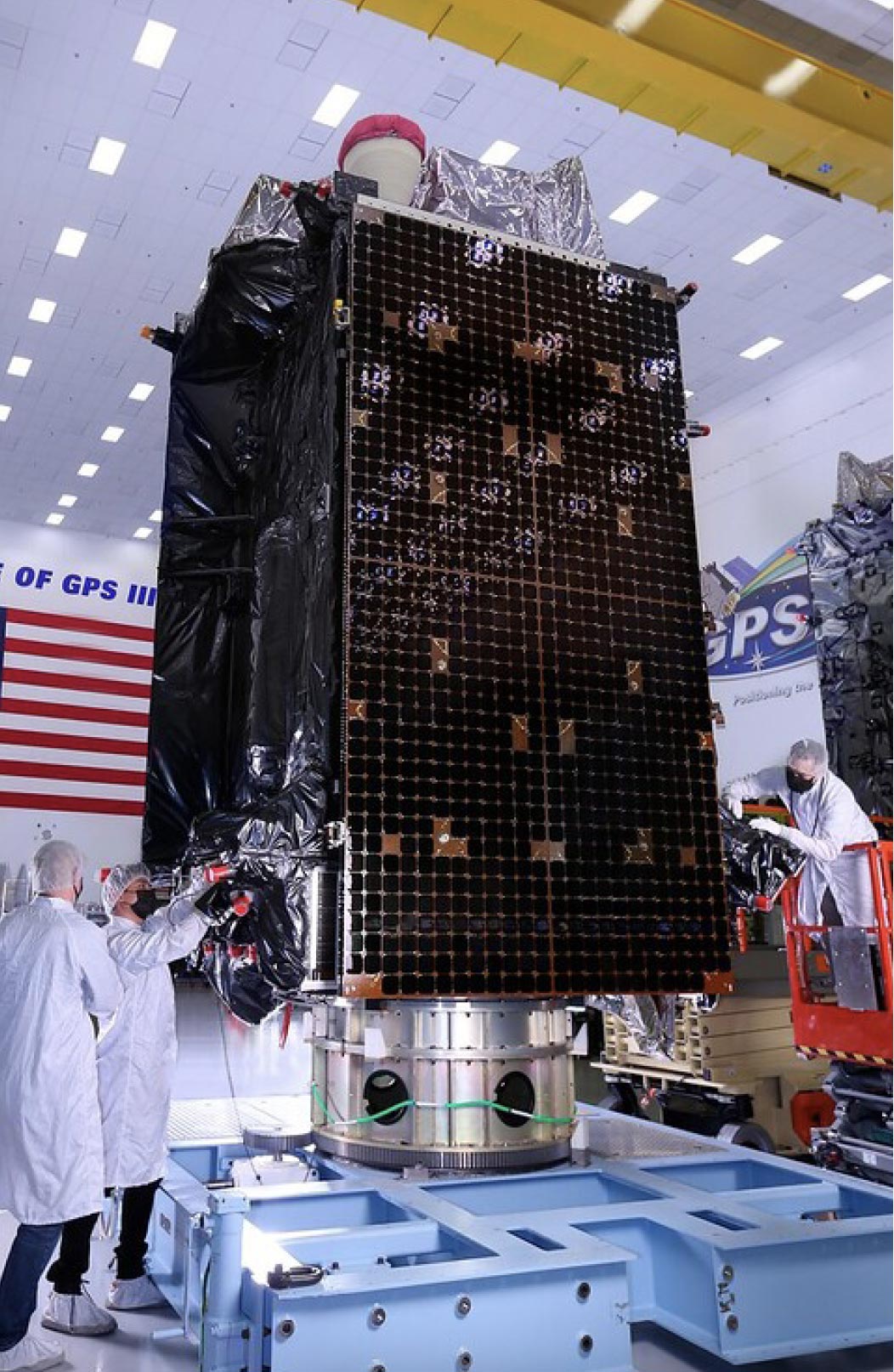
GNSS satellites are not as small as you might think. One of the current generation of GPS satellites (Block III) weighs over 2,200 kg (4,850 lb), the weight of an average pickup truck. The body of these satellites are 1.8 m x 2.5 m x 3.4 m (5.9’ x 8.2’ x 11.2’) in size. Figure 11 shows a picture of the body of a Block III GPS satellite to give you a sense of how large they are.
In the relative vacuum of space, satellite trajectories are very stable and predictable. As mentioned, GNSS satellites know their time and orbit ephemerides extremely accurately. If you ask a GPS satellite for the time, it won’t tell you 8:30, it will tell you 8:31:39.875921346!
The latest generation of GPS satellites use rubidium clocks that are accurate to within ±5 parts in 1011. These clocks are synchronised by more accurate, groundbased cesium clocks. Cesium clocks are so accurate that they would only gain or lose a second after 100,000 years. By comparison, if you have a quartz watch, it likely has an accuracy of ±5 parts in 106 and will lose about a second every two days.
By the way, if all GNSS receivers required a rubidium standard, the viability of GNSS would quickly collapse due to the cost and size of the receiver. Later in the chapter, we will describe the elegant way GNSS systems “transfer” the accuracy of the satellite clocks to GNSS receivers.
You may be wondering why time is such an important factor in GNSS systems. It is because the time it takes a GNSS signal to travel from satellites to receivers is used to determine distances (ranges) to satellites. Accuracy is required because radio waves travel at the speed of light. In one microsecond (a millionth of a second), light travels about 300 metres (328 yards). In a nanosecond (a billionth of a second), light travels about 30 centimetres (1 foot). Small errors in time can result in large errors in calculating position.
GPS was the first GNSS constellation to be launched. The Russian GLONASS, European Galileo and Chinese BeiDou constellations were launched later and are also operational. The benefit to end-users of having access to multiple constellations is accuracy, redundancy and availability. If one system fails, for any reason, GNSS receivers, if they are equipped to do so, can receive and use signals from satellites in other systems. System failure does not happen often, but it’s nice to know that if it did, your receiver may still be able to operate.
Regardless, the ability to access multiple constellations is of particular benefit where the line of sight to some of the satellites is obstructed, as is often the case in urban environments or areas with lots of trees.
GNSS satellites orbit well above the Earth’s atmosphere. GPS and GLONASS satellites orbit at altitudes close to 20,000 km (12,500 miles). BeiDou and Galileo satellites orbit higher, around 21,500 to 36,000 km (13,400 to 22,400 miles) for BeiDou and 23,000 km (14,300 miles) for Galileo. GNSS orbits are more or less circular, highly stable and predictable.
Wind resistance does not affect satellites at 20,000 km (12,500 miles) and higher, but gravitational effects and the pressure of solar radiation do affect GNSS orbits a bit, and the orbits need to be occasionally corrected. While its orbit is being adjusted, a GNSS satellite’s status is changed to “out of service” so user equipment knows not to use the affected signals.
“Everything should be made as simple as possible, but no simpler.”
GNSS satellite signals are complex. Describing these signals requires equally complex words like pseudorandom, correlation and Code Division Multiple Access (CDMA). To explain these GNSS concepts, let’s first discuss GPS satellite signals.
First and foremost, GPS was designed as a positioning system for the U.S. Department of Defense. To provide high-accuracy position information for military applications, a lot of complexity was designed into the system to make it secure and resistant to jamming and interference (see Chapter 7). Although military and civilian components of GPS are separate, some of the technologies used in the military component have been applied to the civilian component.
Since it achieved full operational capability in December 1993, GPS has been available to civilian users, who have different requirements for service availability, positioning accuracy and cost.
The frequency plans (plans that describe the frequency, amplitude and bandwidth of signals) for each GNSS system are a little different. We will describe these plans in more detail in Chapter 3. To illustrate GNSS concepts, however, we will briefly describe the frequency and signal scheme used by GPS, which is shown in Figure 12. Conceptually, this is not much different than the frequency plan for cable or broadcast television channels.
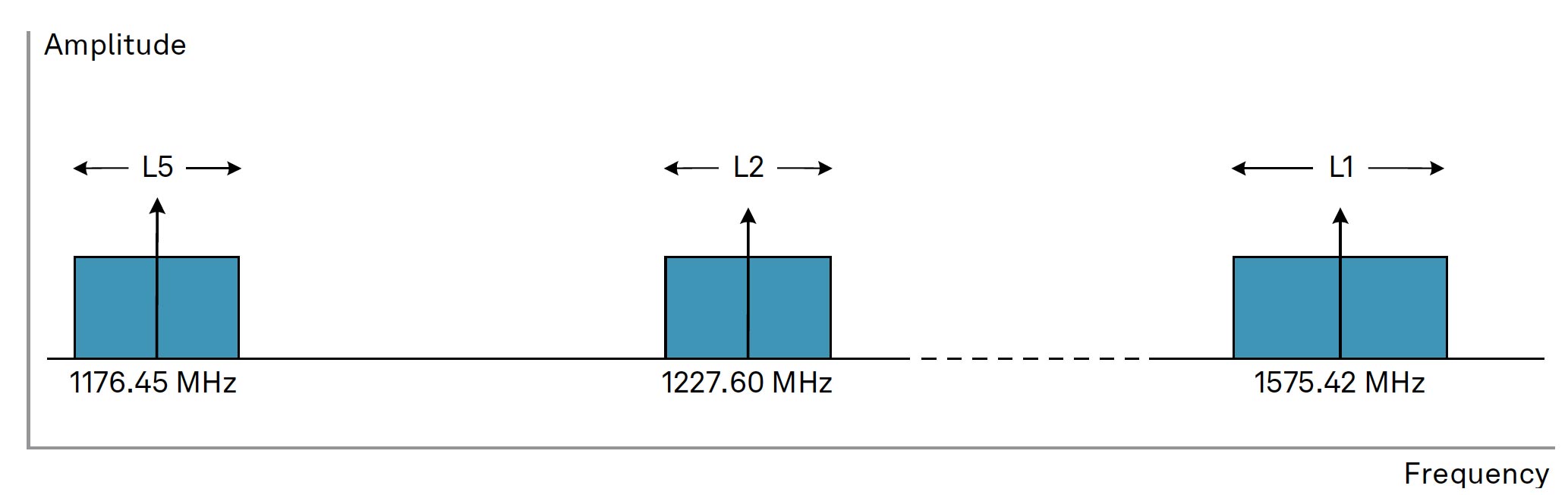
As shown in Figure 12, GPS satellites transmit information on the L1, L2 and L5 radio frequencies. You may ask, “How can all GPS satellites transmit on the same frequencies?”
GPS works the way it does because of the transmission scheme it uses, which is called CDMA. CDMA is a form of spread spectrum (meaning the signal is deliberately spread in the frequency domain resulting in a signal with a wider bandwidth). GPS satellite signals, although they are on the same frequency, are modulated by a unique pseudorandom digital sequence or code (PRN code). Pseudorandom means that the signal only appears random; in fact, it actually repeats after a period of time. Receivers know the PRN code for each satellite, because each satellite uses a different code. This allows receivers to correlate (synchronise) with the CDMA signal for a particular satellite. CDMA signals are received at a very low power level, but through this code correlation, the receiver is able to recover the signals and the information they contain.
To illustrate, consider listening to a person in a noise-filled room. Many conversations are taking place, but each conversation is in a different language. You are able to understand the person because you know the language they are speaking. If you are multilingual, you will be able to understand what other people are saying too. CDMA is a lot like this.
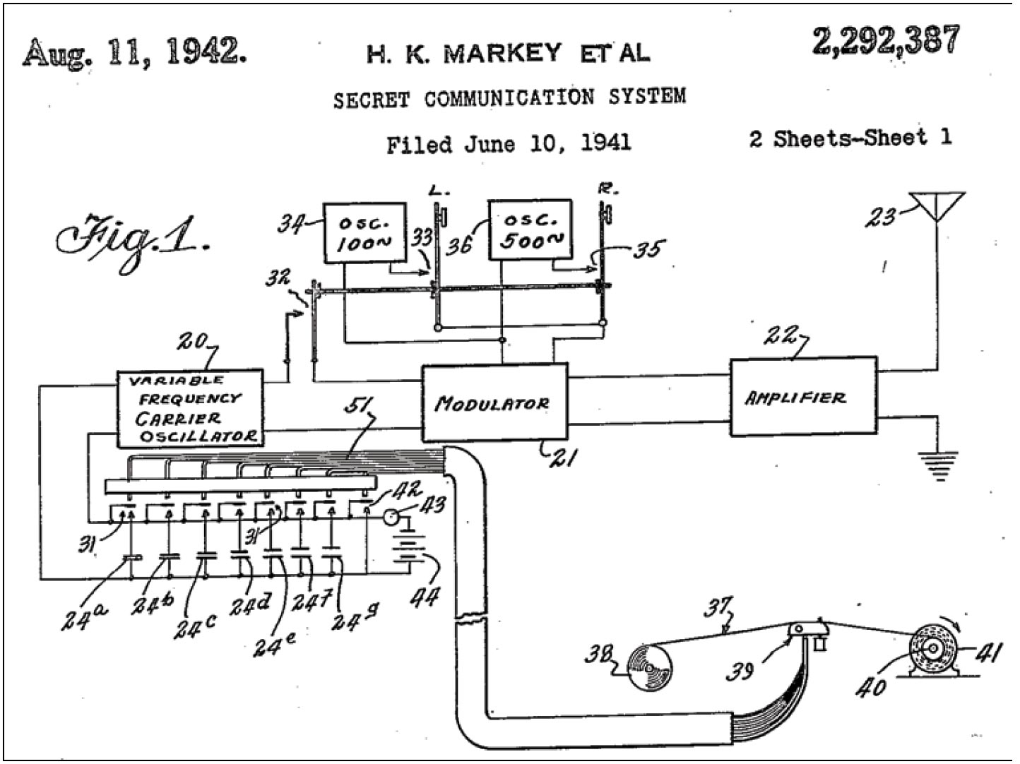
You might be interested to learn that Hedy Lamarr, an Austrian-born American scientist and actress, co-invented an early form of spread spectrum communications technology. On August 11, 1942, she and her co-worker, George Antheil, were granted U.S. Patent 2,292,387. Remarkably, Lamarr shifted careers and went on to make 18 films from 1940 to 1949, but the concepts covered in her patent contributed to the development of today’s spread spectrum communications.
GPS operates in a frequency band referred to as the L-Band, a portion of the radio spectrum between 1 and 2 GHz. L-Band was chosen for several reasons, including:
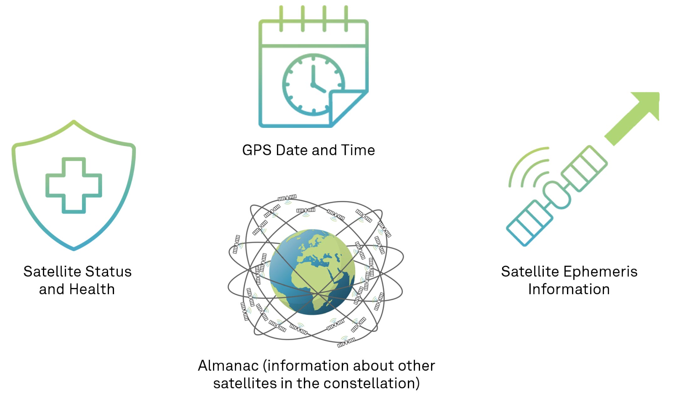
The frequency band was chosen to minimise the effect that weather has on GPS signal propagation. L1 transmits a navigation message, the coarse acquisition (C/A) code (freely available to the public) and an encrypted precision (P) code, called the P(Y) code (restricted access). The navigation message is a low bit rate message that includes the following information:

The P(Y) code is for military use. It provides better interference rejection than the C/A code, which makes military GPS more robust than civilian GPS. The L2 frequency transmits the P(Y) code and, on newer GPS satellites, it also transmits the C/A code (referred to as L2C), providing a second publicly available code to civilian users. Although the information in the P(Y) code is not accessible to everyone, clever people have figured out ways to use the L2 carrier and code without knowing how it is coded.
While the GPS transmission scheme is complex, it was chosen for many good reasons:
Satellite errors include ephemerides and clock errors. These satellite errors are very, very small, but keep in mind that in one nanosecond, light travels 30 cm (1 foot). These small errors can add up to significant errors in the position calculated by the receiver.
GNSS satellites don’t last forever. Sometimes they are phased out with newer models that have new signals or improved timekeeping. Sometimes GNSS satellites do fail and, if they can’t be restored, are permanently removed from service.
Earth stations continuously monitor the satellites and regularly adjust their time and orbit information to keep the broadcasted information highly accurate. If a satellite’s orbit drifts outside the operating limits, it may be taken out of service and its orbit adjusted using small rocket boosters.
In our step-by-step illustration of GNSS in Figure 10, the radio signals have left the satellite antenna and are hurtling earthbound at the speed of light.


