
AGRICULTURE
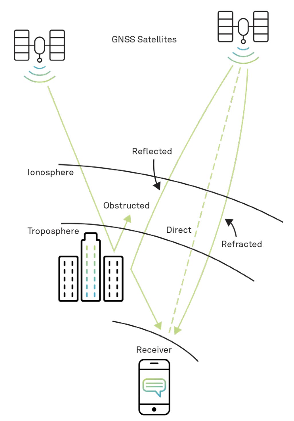
GNSS signals pass through the near-vacuum of space, then through the various layers of the atmosphere to the Earth, as illustrated in Figure 16.
To obtain accurate position and time, we need to know the length of the direct path from the satellite to the user equipment (which we refer to as the “range” to the satellite). As shown in Figure 16, radio waves do not travel in a straight path. Light travels in a straight line only in a vacuum or through a perfectly homogeneous medium. Just as a straw is seemingly “bent” in a glass of water, radio signals from the satellite are bent as they pass through the Earth’s atmosphere. This “bending” increases the amount of time the signal takes to travel from the satellite to the receiver. As we will explain in Step 4, the distance to the satellite is calculated by multiplying the time of propagation (which, you recall, is the time it takes the signals to travel from the satellite to the receiver) by the speed of light. Errors in the propagation time increase or decrease the computed range to the satellite. Incidentally, since the computed range contains errors and is not exactly equal to the actual range, we refer to it as a “pseudorange.”
The layer of the atmosphere that most influences the transmission of GPS (and other GNSS) signals is the ionosphere, the layer 50 to 1,000 km (31 to 621 miles) above the Earth’s surface. Ultraviolet rays from the sun ionise gas molecules in this layer, releasing free electrons. These electrons influence electromagnetic wave propagation, including GPS satellite signal broadcasts. Ionospheric delays are frequency dependent, so by calculating the range using two frequencies (such as L1 and L2), the receiver can resolve the effect of the ionosphere by comparing the propagation time between the two frequencies.
The other layer of the atmosphere that influences the transmission of GPS signals is the troposphere, the lowest layer of the Earth’s atmosphere. The thickness of the troposphere varies by latitude and season, from about 17 km (10.5 miles) in the middle latitudes up to 20 km (12.4 miles) nearer the equator and thinner at the poles. Tropospheric delay is a function of local temperature, pressure and relative humidity. L1 and L2 are equally delayed by tropospheric conditions, so the effects cannot be eliminated the way ionospheric delay can be. It is possible, however, to model the troposphere to predict and compensate for much of the delay.
Some of the signal energy transmitted by the satellite is reflected on the way to the receiver. This phenomenon is referred to as “multipath propagation.” These reflected signals are delayed from the direct signal and, if they are strong enough, can combine with the desired signal, which incorrectly increases the range measurements. Sophisticated techniques have been developed so the receiver tracks the direct signal and ignores multipath signals, which arrive later. In the early days of GPS, most errors came from ionospheric and tropospheric delays, but now more attention is being given to multipath effects, in the interest of continually improving GNSS performance.


