AGRICULTURE

For the last five years, aerial surveying firm RME Geomatics has championed the development, testing, and application of LiDAR-equipped Unmanned Aerial Systems (UAS) throughout Canada.
According to Curtis Parks, general manager at RME Geomatics, the company’s goal is to fill a niche—deliver cost-effective aerial surveying solutions in small and remote areas. He adds, “These are surveys that have not been done previously because they were perceived as too small, too remote, or too expensive for conventional manned aircraft,” Parks says.
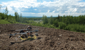
At the heart of the firm’s UAS capabilities is its Renegade™ LiDAR helicopter platform, a tightly integrated and optimized sensor system developed from the ground up to meet the surveying demands of owners in various markets, including agriculture, oil and gas exploration, mining, and forestry.
It was a good plan…with one significant issue. Early in the development of the Renegade™ solution, RME engineers struggled to find a position and attitude measurement system with the right combination of functionality, size, and cost. That all changed when RME’s engineering team shifted from a calibrated magnetometer to NovAtel’s latest small, power-efficient, and lightweight GNSS/Inertial Navigation System (INS) for improved reliability and capabilities at the right price point.
RME engineers tested a number of airframes of varying sizes. In 2012, the firm settled on the helicopter airframe and, over the next two years, focused extensively on operational capabilities, reliability, and flexibility.
Parks recalls, “Our goal in developing Renegade™ is to deliver a system that can gather the right data at the right time for the right cost. A mobile UAS can gather data with very little lead time and without delays common to satellites or manned aircraft.”
In comparison, manned aircraft typically take time to mobilize, and to achieve cost-effectiveness, typically cover large areas during a flight, i.e., hundreds of square kilometres. Similarly, satellite-based imaging systems are expensive due to large base fees, they may not provide the right resolution, and cannot see through clouds.
Parks observes, “In many cases, the owner only wants a small area covered, say a few square kilometres. Ours is a mobile system that is ready at a moment’s notice to map virtually any size area that is needed. It can fly at much lower altitude and at whatever speed; so, data quality is significantly higher than conventional manned systems.”
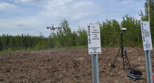
The Renegade™ has a maximum take-off weight of 35 kilograms and a stabilized sensor gimbal. The Unmanned Aerial Vehicle (UAV) has a one-hour flight time that is expandable to two hours with a modular payload of up to 11 kilograms. Optional professional grade sensors include LiDAR, six-band multispectral (450–1050 nanometres), sub-centimetre georeferenced RGB (red/green/blue) imagery, thermal infrared, and video. The UAV doesn’t need a runway and can take off and land in challenging conditions and locales. Data can be processed in near real-time.
At one time, the Renegade™ relied on a magnetometer compass for heading and positioning, a choice that eventually drove the engineers to seek an alternative solution. “We just had too many problems with errors in the autopilot’s heading reading,” explains Parks.
About a year ago, the firm began an extensive evaluation of available lightweight GNSS/INS solutions. Parks adds, “The NovAtel dual– antenna bearing system provided a perfect heading measurement solution and offered increased reliability, directional control and accuracy to the LiDAR system. It was the most capable system at the right price point.”
NovAtel’s OEM617D GNSS receiver card delivers a high-accuracy GNSS positioning and ALIGN® heading solution in real-time, and offers a high-level of performance and reliability in a lightweight, compact, and low-power package. The GNSS card uses a selectable combination of GPS, GLONASS and Beidou to maximize solution accuracy and availability, even in difficult operating environments. The ALIGN heading firmware generates a precise carrier phase positioning solution between two fixed antennas to generate a very accurate heading/pitch solution. RME integrates the OEM617D directly into the Renegade™ autopilot electronics package, replacing the magnetometer and eliminating the previous issues with heading and positioning stability.
RME Geomatics next developed a custom survey payload that includes a NovAtel Synchronized Position Attitude Navigation (SPAN®) GNSS/INS system, which delivers enhanced positioning performance and advanced processing capability. The custom integration consists of the high-end OEM638 GNSS/SPAN receiver for primary positioning and IMU data processing, the OEM615 GNSS receiver for ALIGN heading, and the KVH1750 IMU for high-rate aircraft attitude.
The OEM638/OEM615 dual-board, dual-antenna GNSS receiver pair delivers ALIGN heading, which is important for both autopilot operations and aided alignment of the SPAN INS solution.
“Align gives us heading using dual antennas,” says Parks. “It eliminates issues with having to change magnetic declination in different parts of Canada, interference from ferrous materials on the aircraft, and external environmental factors. Ultimately, it is more reliable than basing everything on a magnetic compass.”
The tightly–coupled OEM638/KVH1750 GNSS/IMU SPAN solution provides a survey payload and sensor package with the high-rate position and attitude information that is needed for direct geo-referencing and high-precision survey data collection. The OEM638/OEM615/KVH1750 components are directly integrated into the custom Renegade™ UAS payload that is optimized for long-duration UAS operations.
RME Geomatics also coupled its LiDAR sensor to the Renegade™ UAS autopilot and used the OEM638/OEM615/KVH1750 for processing. The combined system can gather LiDAR data to an absolute accuracy of 5-15 centimetres with several hundred points per square metre. The system also incorporates integrated direct geo-referencing for simultaneous LiDAR and sub-centimetre resolution imagery without the need to use ground targets or by using fewer targets than other GNSS/INS solutions.
“We use the OEM617D if we are only dealing with autopilot functions and the 638/615 option when we need processing power,” adds Parks.
RME Geomatics also use NovAtel’s Waypoint® Inertial Explorer® software to post-process the collected UAS SPAN survey data. By using Inertial Explorer as part of their survey workflow, the RME Geomatics team has an optimized post-processed position solution with the best possible accuracy for any survey location (using a local base station, CORS network or Precise Point Positioning (PPP)) and with complete quality control of the final combined GNSS/INS trajectory.
Parks points to three benefits of the NovAtel receivers. He says, “First, the NovAtel receivers are reliable. It’s a more robust aircraft-like system. I can take the GPS system anywhere as compared to the magnetometer which had to be calibrated. A second benefit is the precision of the system and third is customer service. This is not plug and play technology. Technical support is critical and NovAtel is the best in terms of support.”
To-date, the Renegade™ UAS has been used on an extensive range of projects from mapping oil fields to LiDAR forest surveys to variable rate application crop mapping to thermal IR mapping and 6-band spectral imaging mine aggregate pits and tailing ponds.
RME Geomatics is the first company to receive Health Canada and Transport Canada for airborne laser payloads in Ontario. Today, RME Geomatics has an unspecified-location Special Flight Operations Certificate (SFOC) issued by Transport Canada for all regions in Canada.