AGRICULTURE

Knowing how deep the water is under one's vessel has been a must for safe navigation for thousands of years. With the rise of maritime trade and naval warfare, highly valuable and strategic charts derived from seafloor mapping became closely guarded secrets. Today, governments, militaries, telecommunications and petroleum companies, academic institutions and many more continue to chart the seafloor for a variety of reasons.
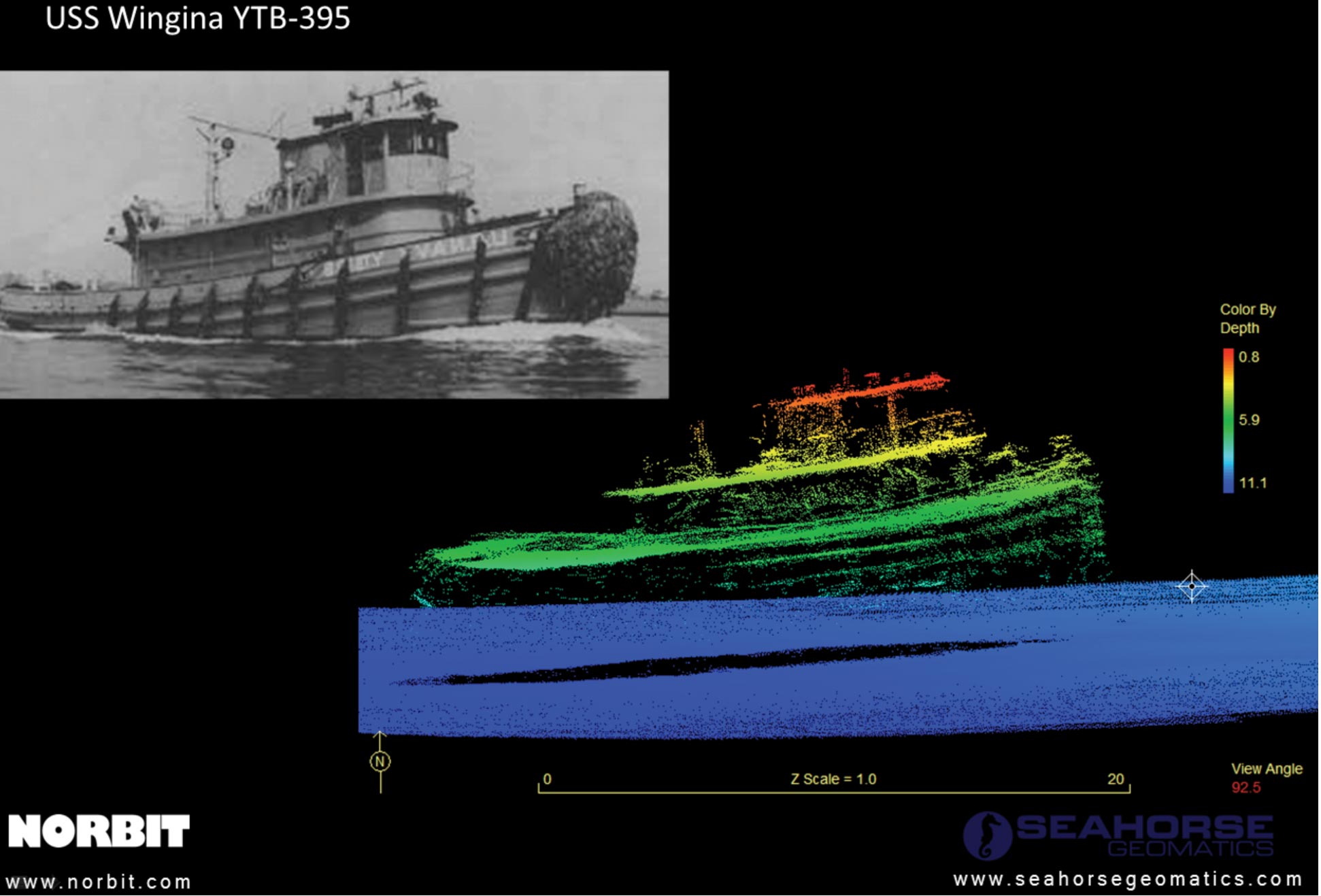
Figure 1: The USS Wingina, photo and scan.
The stage thus set, enter Norbit's new iWBMSc mulitbeam sonar, featuring NovAtel's Synchronized Position Attitude Navigation (SPAN) system.
“There are really three major components here,” explains NovAtel's Ryan Dixon. “The Inertial Measurement Unit (IMU) is manufactured by Sensonor. NovAtel manufactures the GNSS and interface cards, and the real technology element that NovAtel provides is the SPAN system, an Inertial Navigation Solution (INS) using both GNSS and the Sensonor IMU. Norbit then makes the multibeam sensors, which incorporate all of these components.”
The IMU Dixon is referring to is Sensonor's STIM300, a Micro Electromechanical Systems (MEMS) device for weight and size constrained environments, replacing previous bulky and cumbersome systems.
“The finished product is vastly simpler for an end customer to install,” says Dixon. “Instead of having a totally separate INS system to plug in alongside the existing items like the computers and multibeam, all of the navigation equipment is directly and invisibly embedded into the multibeam equipment. It's like going from an aftermarket GPS glued to the dashboard to a built-in unit.”
Bathymetry is the marine equivalent of topography and it generally involves the use of a sonar transducer that transmits a sound pulse from the surface and records the returning signal as it bounces back from the bottom.
Bathymetric surveys need to be completed within a reasonably short period of time in order to be cost-effective. A dedicated survey vessel is expensive to operate, especially in rough and remote deep-sea environments where the ship must be large enough to ride out rough ocean weather and where a highly skilled crew and scientific staff may be lodged for days or weeks at a time.
Multibeam sonars can transmit and receive a large number of 'pings' at once, thus covering a wide swath of seafloor in a single sweep. While being the instrument of choice in today's mapping applications, to be most accurate, measurements must take into account the movement of the instruments on the surface of the water.
Horizontal and vertical positioning is generally measured using GNSS receivers and IMUs. The IMUs need to be mounted very close to the transducer to minimize any potential error due to the offset between them.
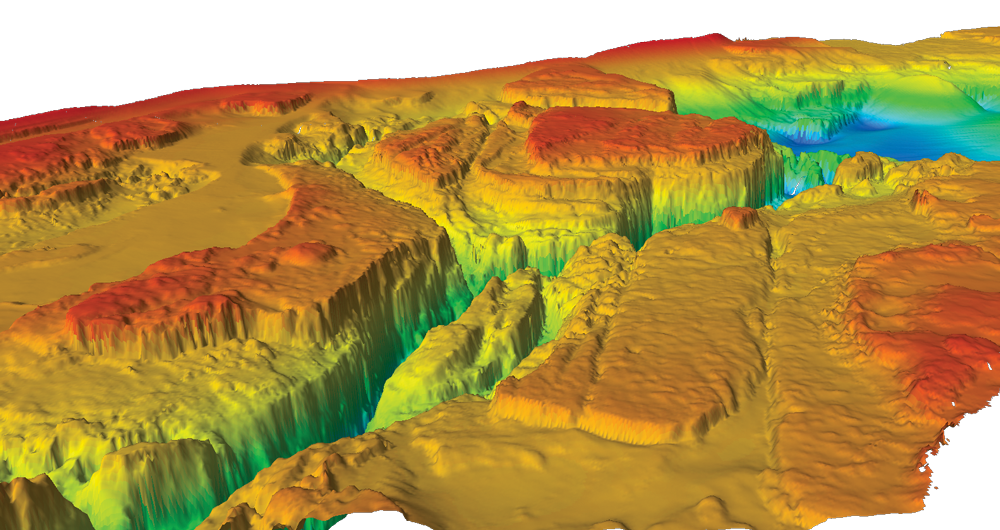
Figure 3: Underwater canyons revealed.
The new Norbit iWBMSc eliminates many of the problems associated with conventional multibeam sonar; because the SPAN system is completely integrated into the sonar unit, there is no additional error as when these units are mounted in different parts of the vessel. The system directly senses the motion of the sonar because it is actually a part of the sonar unit.
Dixon describes the advantages: “The IMU needs to be precisely mounted-already done for you; the distance between the IMU and antenna needs to be precisely measured-already done for you; and all sorts of cabling etc. needs to be run between all the different boxes-also taken care of. So from a simplicity point of view, there is much less that can go wrong with this system while still maintaining a very high degree of accuracy.”
Peter Koldgaard Eriksen is Business Development Director at Norbit Subsea US Ltd. His relationship with NovAtel goes back to his 'previous life' within the industry, he says, with another company within the industry. Since then he has kept NovAtel in his sights.
Figure 4: The iWBMSc in action.
“Norbit knew what it wanted for the new multibeam sonar system,” he says. “We knew we needed GNSS in our system, and we wanted something very compact. But we also knew that conventional motion sensors would not fit inside our unit. And on top of that, we were very pricesensitive.”
At various meetings and every single trade show, he says, “we could see what NovAtel was doing and it was very clear that we would eventually work with them on our new system; NovAtel was definitely on our road map.”
Norbit understood the potential implications of putting a small IMU inside their multibeam sensor head, and like NovAtel they were really just waiting for the right IMU to come along. When Sensonor, based in Norway, created that IMU in the STIM300 and NovAtel demonstrated its potential in its SPAN system, Norbit could see the sonar unit they had always wanted to create was now possible.
“It was a matter of time,” Eriksen says. “Looking at the GNSS sector, those units just keep getting cheaper and cheaper, and smaller and smaller. With motion sensors as well, the gap was narrowing.”
Figure 5: Norbit Subsea Magnus Andersen fits a seagoing kayak for bathymetric surveying.
“We did look at different options, but for our mulitibeam sonar, the NovAtel solution came out on top. This is the first fully MEMS-based system of this type, and it came with a reasonable price tag,” says Eriksen.
“NovAtel's OEM technologies provide us with robust, compact solutions to further enhance our offerings to our customers. Through this collaboration, we are opening new possibilities and industry-changing innovation which will set us apart and benefit the people who use our equipment.”
Figure 6: 3D Hillshade image of the Columbia River upstream of The Dalles Dam, Oregon. Depths between 4m and 76m below water level.
Ryan Dixon says an advantage for NovAtel when creating a GNSS +INS solution from one of its GNSS boards is that the company's engineers understand, in the minutest detail, how those GNSS boards function. “We have access to every bit of information, and what this allows us to do is create a much more robust solution in all respects.” both worked for the same company. When Mutschler left that company to found Seahorse, and Eriksen went to work for Norbit, the two continued to collaborate. Between them they offer over 35 years of industry experience.
Today, Seahorse Geomatics is the NovAtel marine SPAN dealer worldwide. They are also the North American dealer for NORBIT and a key partner providing services world wide. Much of the initial phase evaluation and testing of the new Norbit sonar system was carried out by Mike Mutschler and his team at Seahorse.
Mutschler explains: “Seahorse Geomatics was contacted by Norbit in 2012 to provide a practical bathymetric surveying context for the development of their all-new curved-array multibeam sonar system.”
Since 1998, he says, Seahorse has been involved in the marine surveying sector, providing seismic surveying, offshore positioning, dredging, coastal engineering, geological sciences, acoustic sensor manufacturing and services in hydrographic disciplines. “This put us in a good position to help Norbit sonar developers to better understand the challenges associated with bathymetric mapping and therefore direct R&D efforts towards solving or simplifying these from the ground-up,” Mutschler says.
“The resulting Norbit iWBMSc is a tightly integrated, wide-swath multibeam sonar kit with co-located attitude and coupled GNSS/INS solutions in a small form factor. The critical requirement to meet or exceed strict specifications, as published by the International Hydrographic Organization, US Army Corps of Engineers, Rijkswaterstaat, etc., is maintained.”
Seahorse Geomatics and Norbit are linked, Mutschler says, “in a boundary-free synergistic working relationship that combines discrete passions for acoustics pioneering and increasing bathymetric mapping efficiencies.” The result is the most compact high-performance sonar available, a revolutionary bottommapping solution capable of delivering waterdata products of the highest quality.
In addition to providing key technical input, says Eriksen, “Mike is our go-to-market partner. He does our system testing and client contact. He represents our products at trade shows and performs demonstrations.”
Mutschler says the Norbit iWBMSc system is broadband-enabled, allowing up to 80 kHz FM pulses centered at 400 kHz, and incorporates a curved receiver array of multiple piezoceramic elements. “This allows for narrow beams to be maintained across a wider angular swath width than typical planar/flat receiver arrays.” This results in smaller beam footprints on the bottom surface for increased data resolution and accuracy.
Multibeam sonar systems are most often mounted on floating or submerged survey vessels that are heading, pitching, rolling, heaving in different directions, with varying dynamics at play on or under water surfaces. The Norbit multibeam sonar measures several hundred beams, each having a unique two-way travel time and across-track pointing angle from nadir which must be combined with accurate survey platform positioning, attitude-roll, pitch and heading and sound speed to derive a final and repeatable XYZ location on a common projection.
“When the different sensors are separated, vertical and horizontal uncertainties are increased due to offset measurement errors, sensor misalignments and platform flexing,” Mutschler explains. To solve this, Norbit puts the NovAtel GNSS +INS deep within the sonar hardware.
“The STIM300 IMU is situated directly inside the already compact sonar head,” says Mutschler. “The benefits include fixed and very small lever arm offsets which effectively eliminate sensor-to-sensor flexing, simple setup and integration with a single LAN cable for complete data acquisition on a laptop, and a compact size for simple mounting on nearly any sized platform, from a sea kayak to a large survey ship.”
NovAtel's Ryan Dixon states: “The big deal here is that we are getting a level of correction in relation to price not available in the past. Because of the integration there is less possibility of error.”
Mutschler describes a key application for the new system: “In the case of safety of navigation, vessel captains and pilots regularly assess the risk level of entering a port utilizing charted information that includes hydrographic data on bottom depths and material type.” They may decide, he explains, to allow the keel to be plowed some 30-90 cm through a sandy or muddy bottom and thereby promptly deliver time-sensitive cargo, as opposed to waiting for high-tide conditions. “This is not an unusual practice. Often, keel drag marks are noticeable in many port entrances such as in New Orleans, Rotterdam or Jeddah.” Here, extremely accurate bottom depth figures as well as bottom type are clearly critical for daily risk assessments by ship navigators.
But it isn't just about oceans and port bottoms. Hydrologists and engineers just as often require accurate water-depth measurements and information about sub-bottom stratigraphy in shallow freshwater lakes and rivers. Specific applications can vary from estimating available water volumes to the design of new structures such as bridges or pipeline crossings.
In many small lakes, weed-infested waters and fast-flowing streams, it can be quite difficult to get reliable data on water depth or to define bottom and sub-bottom structures. Meanwhile, the use of large boats with conventional acoustic sounding equipment is often not possible, which is where compact and flexible solutions like Mutschler's kayak come in.
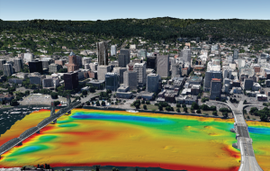
Figure 7 and 8: Portland Oregon, survey under bridges of the Willamette River using the NORBIT WBMS integrated with NovAtel SPAN.
“Typical applications requiring increased focus on least-depth mapping include those for waterways and infrastructure,” he says, “for safety of navigation to support commerce, bottom depths and characterization for fisheries, scour mapping for coastal wind farms, bathymetric morphological processes for geological sciences, detailed bottom detections for archeological assessments, etc.” All of these require highly detailed and repeatable bathymetric mapping. Such projects are often located in remote areas and therefore require mobilization efforts that can be greatly simplified with a purpose-built and easy-to-use kit.”
Peter Koldgaard Eriksen says the new system has been very successful. NORBIT Subsea is currently in the process of reallocating jobs and hiring new people, scaling up to meet the challenge of market production. Eriksen says, “We want to do everything we can to make sure we get into the market as soon as possible. We feel like Subsea is entering a new phase of life.”
Figure 8:
“But,” he cautions, “the world is changing as we speak, especially in the area of motion sensor components and microelectronics in general. Established players are used to working on longer time schedules, but this war is going to be won by the people who are most adaptive and quick." Eriksen added, “We are going to see a rapid evolution. We need to keep going, to keep looking at new sensors, new systems and new approaches, left and right.”
What NovAtel and Seahorse Geomatics have accomplished represents a major step forward, and a clear demonstration of how the right partnership can find powerful and innovative solutions to some of the world's oldest problems.
Download the latest edition of Velocity magazine.