
AGRICULTURE
Global navigation satellite systems (GNSS) are invisible pieces of technology that people rely on everyday without thinking about it. From communications systems to mobile navigation applications like Google Maps, GNSS affects what we do every day. But what are global navigation satellite systems?
In this blog post, we’ll explain what GNSS are, including its history and how they are used today. We also compare the different GNSS constellations and their features, as well as the equipment necessary to access GNSS signals. By the end of this introduction to GNSS, we hope you’ll better understand and appreciate this invisible piece of everyday technology.
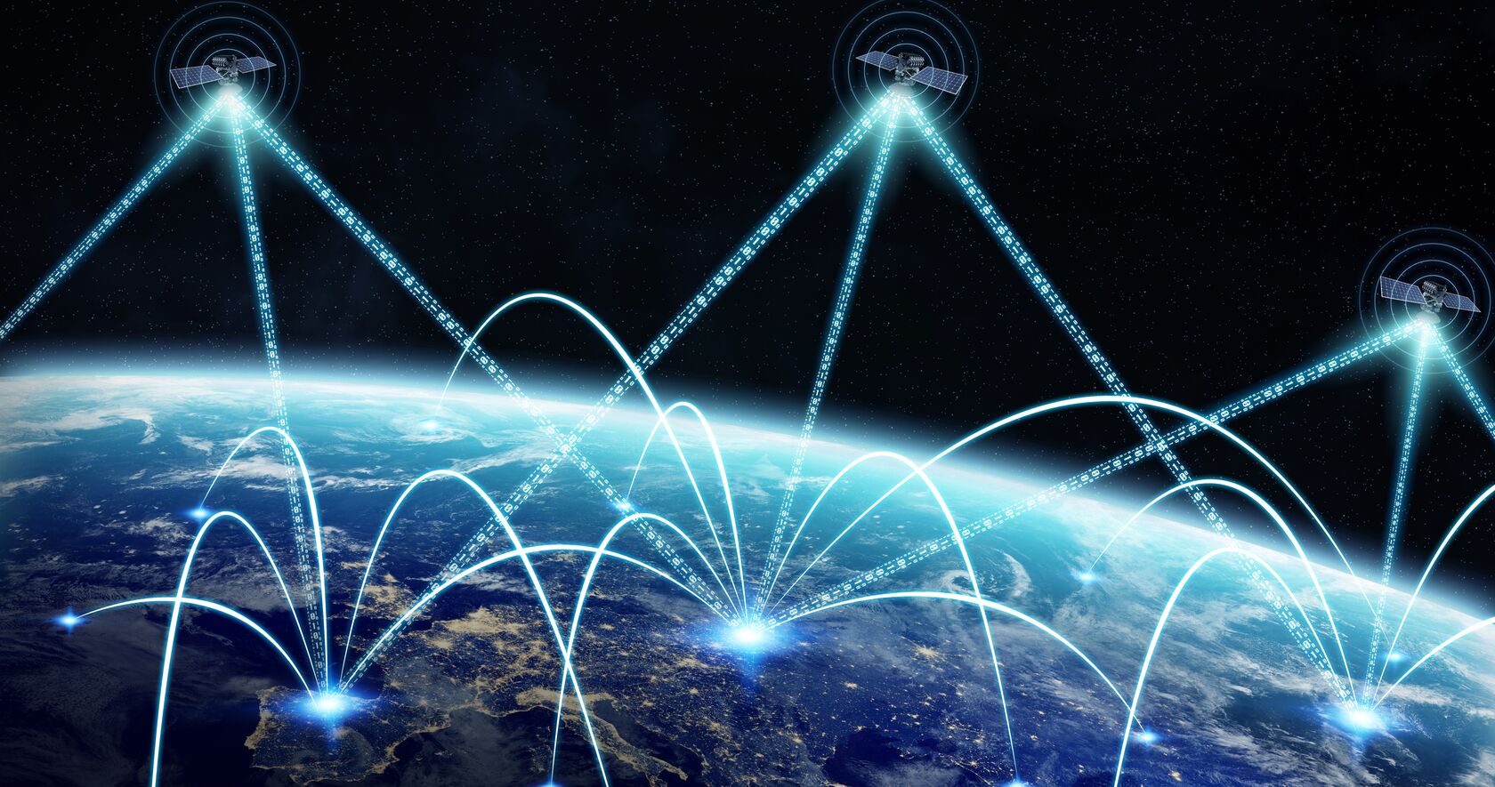
A global navigation satellite system (GNSS) is a network of satellites broadcasting timing and orbital information used for navigation and positioning measurements. Our Introduction to GNSS webinar series goes into more detail about how GNSS works, but a simplified version is that satellites transmit signals that report where they are at what time, with that information being used to determine where you are in the world. Through a complex series of trilateration calculations, your technology computes your location based on your position in relation to at least four satellites.
GNSS are more than the satellites orbiting Earth. The multiple groups of satellites, known as constellations, broadcast signals to master control stations and users of GNSS across the planet. These three segments – space, control and user – are all considered part of GNSS. But most frequently, GNSS is used to describe the satellites in space.
The space segment describes the GNSS constellations orbiting between 20,000 to 37,000 kilometres above the earth. These satellites broadcast signals that identify which satellite is transmitting and its time, orbit and status or health. There are four main constellations in orbit – GPS, GLONASS, Galileo and BeiDou as well as two regional systems QZSS and IRNSS – and each are managed by a different country.
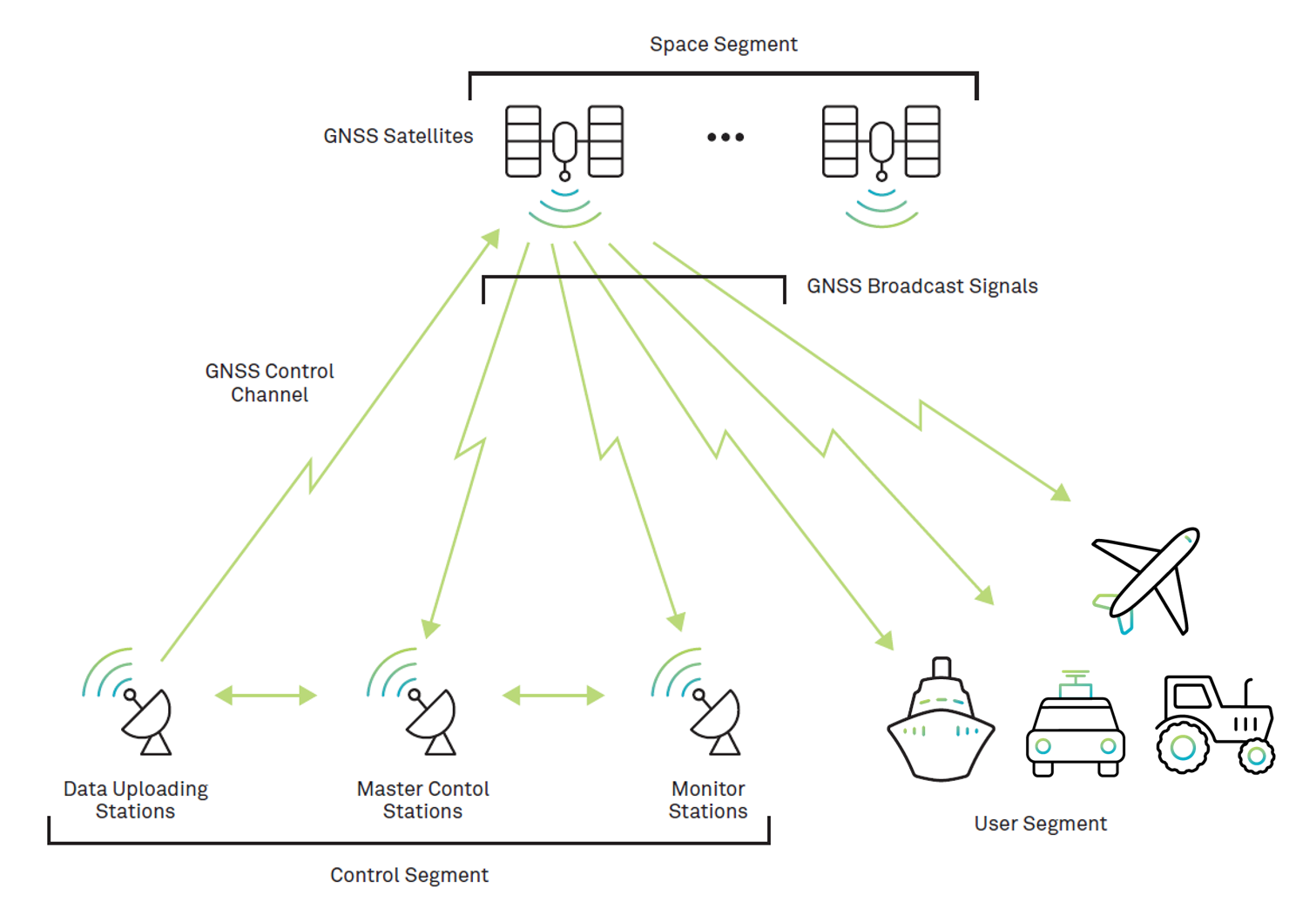
The control segment is a network of master control, data uploading and monitoring stations located around the world. These stations receive a satellite’s signal and compare where the satellite says it is with orbit models showing where it should be. Operators at these stations can control the satellites position to correct or alter their orbital paths, for example if a satellite has drifted, or needs to be moved to avoid debris collision. This process, as well as monitoring a satellite’s health, ensures a baseline of accuracy in GNSS positioning.
The user segment includes the equipment that receives satellite signals and outputs a position based on the time and orbital location of at least four satellites. This segment includes the user’s antennas to identify and receive good-quality signals as well as high-precision receivers and positioning engines that process the signals and resolve potential timing errors.
We’ll go into more detail about where GNSS positioning is used in different industries below, but every GNSS application relies on these three segments to function.
The basis of GNSS and its technologies is in using radio waves for communication and tracking a position. These efforts were applied to space when the Soviet Union launched Sputnik 1 into a low orbit in 1957.
Sputnik, Earth’s first artificial satellite, transmitted radio pulses for scientists to learn about the density of our atmosphere and to test radio and optical methods of orbital tracking. Due to the political climate, it also sparked the Space Race between the USSR and USA. American scientists tracked Sputnik’s radio pulses using the Doppler effect, a method that eventually led to the Navy Navigation Satellite System, also known as Transit.
Transit became the first satellite-based geo-positioning system in 1960 and was used primarily by the Naval service starting in 1964. This positioning technology was still based around using the Doppler effect to determine your position to or from a satellite, which only provided sub-metre accuracy.
To calculate a more accurate position, the US Navy developed the Timation satellite that would broadcast an accurate time reference for a ranging signal. This new approach to satellite positioning – of a satellite broadcasting its location and specific time at that location – was the precursor to the United States developing the Global Positioning System (GPS), launched in 1973.
The Soviet Union, meanwhile, used what they learned from Sputnik 1 to develop their own satellite navigation system called Parus in 1974. While Parus was designed for use by the Russian military and likewise GPS for the US military, satellite positioning systems were made accessible worldwide in 1983.
In September of that year, Korean Air Lines flight 007 experienced a navigation error, resulting in their flying into Soviet airspace and being shot down. As a result, GPS was designated to be available to anyone, anywhere, setting a precedent for all navigation satellite signals to be globally available and for civil, commercial and governmental initiatives.
Satellite navigation system constellations continued to develop: the Soviet Union’s Parus eventually expanded into the Global Navigation Satellite System, as GLONASS in 1982; China introduced their system BeiDou in 2000; Japan’s Quasi-Zenith Satellite System (QZSS) in 2010; the European Union launched Galileo in 2005; and, India’s Indian Regional Navigation Satellite System (IRNSS) in 2013, now known as NavIC. These constellations continue to be refined and expanded by the addition of satellites into their constellation, as well as the broadcast of different signal types.
Earth’s first artificial satellite, Sputnik 1, sparked a line of science and engineering leading to nearly 150 satellites in orbit across the GPS, GLONASS, BeiDou and Galileo constellations.
A global navigation satellite system (GNSS) is the generic term for any of the satellite constellations that broadcast positioning, navigation and timing data. There are four main constellations and two regional constellations worth highlighting.
These constellations use radio frequencies in the L-Band to transmit their signals, however each constellation may choose different frequencies and corresponding labels for these signals. GNSS positioning equipment typically receives at least two frequencies, which more specialty equipment able to receiver additional L-Band signals.
Important to note are Satellite-Based Augmentation Systems (SBAS) which provide global error corrections for improved accuracy in GNSS applications. Many countries manage their own SBAS systems and these are usually considered separate from traditional GNSS constellations.
GPS is operated by the U.S. Space Force, a branch of the U.S. Armed Forces. It was the first constellation to be established in space with its first satellite being launched in 1978, with its first series of satellites fully operational by 1993.
Currently the system has 31 satellites in orbit supporting L1 (1575.42 MHz), L2 (1227.60 MHz) and L5 (1176.45 MHz) frequencies.
GLONASS was first developed in the Soviet Union to compete with GPS during the ‘70s and is currently operated by Roscosmos State Corporation for Space Activities, a department in the Russian government. The first GLONASS satellite was launched in 1982 and today has 24 satellites in orbit.
The constellation was fully launched and completed in 1995, with full satellite coverage achieved across Russia in 2010.
GLONASS satellites broadcast signals on GLONASS L1 (1598.0625-1605.375 MHz), L2 (1242.9375-1248.625 MHz) and L3 (1202.025 MHz) frequencies.
Galileo is a more recent constellation first launched in 2011. Operated out of the European Union by the European Global Navigation Satellite Systems Agency, Galileo currently has 26 satellites in orbit, with a plan to reach 30 satellites by 2021.
These satellites transmit along the L-Band spectrum, labelling their frequencies E1 (1575.42 MHz), E5 (1191.795 MHz), E5a (1176.45 MHz), E5b (1207.14 MHz) and E6 (1278.75 MHz).
First launched in 2000, BeiDou operates out of China by the China National Space Administration (CNSA). In the 20 years since, BeiDou has 48 satellites in orbit.
BeiDou satellites currently transmit many signals, including B1I (1561.098 MHz), B1C (1575.42 MHz), B2a (1175.42 MHz), B2I and B2b (1207.14 MHz) and B3I (1268.52 MHz).
Japan’s Quasi-Zenith Satellite System (QZSS) is operated by the Japan Aerospace Exploration Agency (JAXA) and was first launched in 2010. While the other constellations have provided global coverage, QZSS maintains Asia-Oceana regional coverage between Japan and Australia.
As a regional constellation, QZSS only has four satellites currently in orbit, with a plan for an additional three satellites in the few years.
QZSS signals transmit at the same frequency as GPS L1 (1575.42 MHz), L2 (1227.60 MHz), L5 (1176.45 MHz) as well as L6 (1278.75 MHz).
Another major regional constellation is the Indian Regional Navigation Satellite System (IRNSS) operated by the Indian Space Research Organization (ISRO) out of India. IRNSS is also known as NavIC (Navigation with Indian Constellation) and includes eight satellites in orbit.
The constellation’s coverage centers around India, reaching west to include Saudi Arabia, north and east to include all of China and as far south to include both Mozambique and Western Australia.
NavIC signals transmit on the GPS L5 frequency (1176.45 MHz) as well as along the S-Band (2492.028 MHz).
| Operator | Coverage | Altitude (km) | Satellites in Orbit | |
|---|---|---|---|---|
| GPS | US Space Force | Global | 20,180 | 31 |
| GLONASS | Roscosmos | Global | 19,130 | 24 |
| Galileo | GSA and ESA | Global | 23,222 | 26 |
| BeiDou | CNSA | Global | 21,528 (MEO satellites) 35,786 (GEO and IGSO satellites) |
48 |
| QZSS | JAXA | Regional | 32,000 (perigee) 40,000 (apogee) |
4 |
| IRNSS/NavIC | ISRO | Regional | 36,000 | 8 |
GNSS applications rely upon satellite signals to complete their task efficiently and accurately. These applications range across many different industries – from agriculture to automotive to defense – but generally will fall into five major categories:
For example, farmers need consistent routes over their fields to optimize seeding, fertilizing and harvesting. They rely on GNSS for their location and tracking of their equipment. In some cases, farmers may use GNSS to map their fields before planning their routes.
In the automotive space, vehicles use GNSS for location and navigation purposes. If the vehicle is autonomous, then tracking becomes even more important to continuously monitor potential hazards in the environment.
GNSS is used in aerospace for location, navigation, tracking and timing – the United States Federal Aviation Administration uses timing information from GNSS satellites to synchronize hazardous weather reports across the country.
Episode seven of our Introduction to GNSS webinar series goes into further detail about how diverse applications use GNSS.
There is a range of GNSS equipment that has been developed to support different applications across a variety of environments. At its most basic, to use GNSS you require an antenna and a receiver.
Antennas act like a gatekeeper to satellite signals by accepting high-quality signals and rejecting low-quality ones. A range of antennas have been developed to best support different applications, including compact antennas, fixed reference antennas and high-performance low size and weight antennas.
Receivers are available as OEM receiver boards for users to install into their existing solution, or within an GNSS enclosure ready to be used. Receivers do the work of de-modulating the satellite signal and computing the user’s position, navigation or timing measurements. Because users require both an antenna and a receiver, Hexagon | NovAtel developed smart antennas that already combine the two technologies into an all-in-one solution.
Depending on the application’s need for precision, signal resilience and reliability, there are additional technologies that enhance the performance of GNSS receivers.
These additional technologies are often included within receiver enclosures, like NovAtel’s GNSS and inertial SPAN technology. Inertial navigation systems (INS) and their inertial measurement units (IMUs) integrate heading, velocity, attitude and heave motion measurements with GNSS measurements for a more complete and three-dimensional understanding of your position.
If users are operating in environments where there may be attempts to jam GNSS signals, or falsify position, navigation and timing coordinates (also called spoofing), they may invest in anti-jam solutions. NovAtel’s GPS Anti-Jam Technology (GAJT) helps protect users’ antennas from being jammed or spoofed so they can continue receiving GNSS satellite signals to their receivers – like what we see in this case study from the British Army’s Light Dragoons. In some cases, firmware like NovAtel’s GNSS Resilience and Integrity Technology (GRIT) can be added onto GNSS receivers to build a more resilient and robust positioning system against jamming and spoofing attacks.
Across all environments and all applications, users often rely upon GNSS correction services to augment their solution’s accuracy and reliability. Correction services are available in either a Real-Time Kinematic (RTK) method, or through Precise Point Positioning (PPP). These services help mitigate and resolve positioning errors from atmospheric and ionospheric activity, multipath effects, orbital errors, satellite clock errors and more. The Satellite-Based Augmentation Systems (SBAS) mentioned earlier are one example of correction services, but there are many subscription-based services available that provide greater accuracy, availability and reliability.
Many technologies, algorithms and innovations have been developed and refined to optimize GNSS satellites for position, navigation and timing. Many solutions rely upon a combination of the above technologies to use GNSS to their advantage.
GNSS does far more than supporting Google Maps. In this blog post, we’ve highlighted the technologies, organizations and real applications that support, innovate upon and use GNSS for position, navigation and timing. With over 70 years of development, GNSS is at the core of our everyday lives – this sentiment will only become more true as GNSS-based autonomous applications like self-driving cars become more ubiquitous.
Download our Introduction to GNSS book to learn more about GNSS


